Company Details
Location
Evergreen, Colorado
Founded
1997
Ownership Type
Private
Employees
22
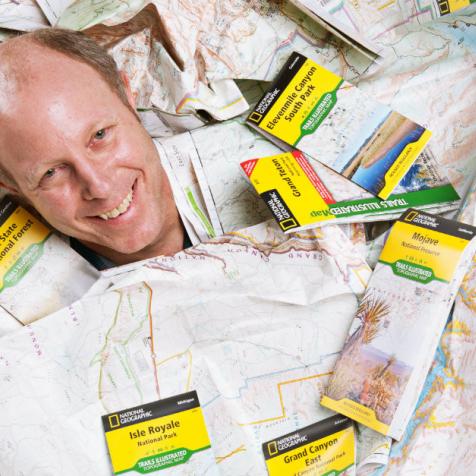
Products
Maps
shop.nationalgeographic.com/ngs/category/maps
Evergreen, Colorado
Purchased: 1997
Owned under National Geographic Partners (a partnership between the National Geographic Society and 21st Century Fox)
Employees: 22
With 21st Century Fox as a new partner, the venerable science organization's map-making division has launched new product lines and experienced stellar growth.
National Geographic purchased Evergreen-based Trails Illustrated Maps in 1997 and kept it there. "It turned out to be a really fantastic acquisition for us," says Dan Ortiz, vice president and general manager of National Geographic Maps.
Ortiz was part of the team that led the acquisition. "Not only did it get us into the commercial mapping business but we inherited really strong relationships with the land management agencies," he says. "The model that Trails Illustrated had set up for building maps was to work very closely with the land managers and get digital content from them to help build the base maps and we were able to continue that process."

Ortiz doesn't expect the partnership with Fox to change much for his division of the company. "We've been operating sort of as a for-profit business since 1997," he explains. "There is the exciting possibility of potential new investment on the digital side."
Meanwhile, the division has experienced record growth with its backcountry maps, which are printed at Sprint in Denver on Hop-Syn, a tear-resistant and waterproof material, and an expanding line of U.S. and international maps. It has also added some new accounts but existing dealers and distributors are selling more maps, according to Ortiz. "We've made a lot of product improvements," he notes.
"The Trails Illustrated printed product line is growing really strongly. It looks like we'll see about 20 percent growth this year over last year," says Ortiz, citing economic improvement and increased outdoor recreation as catalysts.
"This type of mapping is essential when you're going outdoors," he adds. "You certainly can't rely on a smartphone in the backcountry. When you use tracking apps, it really drains the battery."

The company also launched a highly successful international line of maps called the Adventure Line. "In two years, it went from 14 titles to 84 and we just added Jamaica, Cambodia, Namibia, and Myanmar," Ortiz explains.
In the U.S., National Geographic's maps division is the only organization offering hiking maps across most of the U.S. "Our competitors are regional or small individual publisher companies. It's kind of complicated," Ortiz says of the competitive landscape. "There is no other national outdoor recreation mapping company that we're going head to head with."
Still, with 56 maps in print, the division has more maps covering Colorado than anywhere else, including California. Expect more. "We are going to make a real concerted push for Colorado products in 2016 because we're releasing these four booklets two Colorado Trail and two on 14ers," Ortiz says. "Colorado is our deepest list of independent dealers in any state."

The booklets he's referring to are another new product line. "We were looking for a way to find an efficient format to map a linear feature like a river. There was an opportunity but it didn't seem to be a huge market. We diverted our attention from mapping a linear river and thought maybe this would work really well for a long distance feature like a trail." The division launched the first, the John Muir Trail Topographic Map Guide, in 2014. "It has done extremely well," says Ortiz. "The Appalachian Trail products are just getting into the market but early indications are really strong there, as well."
Challenges: "The main challenge is making sure that we produce enough of our content in the right digital formats going forward," Ortiz says, adding that printed maps won't disappear anytime soon but the growth of mobile digital content is huge.
![]()
Opportunities: Continuing to grow the outdoor recreation segment, according to Ortiz. "There are a lot of areas we still haven't mapped thoroughly. We're just starting to break into the Northern Rockies. Idaho and Montana represent really interesting areas to us," he says. "Long-distance trails are a big opportunity. We haven't jelled all our plans, but we do feel this format could be extended to international destinations."
Needs: "We're running smoothly more here but additional investment and research into the digital side is always a need," Ortiz says.